I feel like I'm starting to sound like a broken record because yet again, not much concerning the weather has changed since yesterday. The continental polar air mass is still here, as is the high-pressure system to our southwest. This high pressure has led to a consistent southwest wind bringing in warmer air, which has gradually increased the temperature over the last couple of days.
As I walked into school early this morning, the sky was almost entirely clear and blue to the south. Most of the sky to the north was covered in a combination of altostratus and cirrus clouds. Overall, I estimate the cloud cover wasn't over 25% early this morning. However, that changed to nearly 100% by this afternoon.
On my walk home, the cloud cover had drastically decreased. I made a point to look at the flag on top of Schofield, and that was barely waving at the time (if at all). The temperature was fairly warm.
I predict that tomorrow will be even warmer than today. A warm front (shown in the first map below) has developed to our west, which contains a mass of warmer air behind it. In addition, a cold front has also developed to our northwest. Thus, there will more than likely be some dynamic changes in the near future. The second map (below) shows a concentration of water vapor farther west. This cold front and concentration of water vapor could lead to some snow late tomorrow or Sunday.
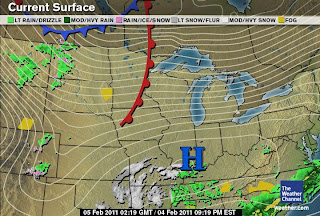 |
Current surface map from The Weather Channel. A warm front
has developed to the west and a cold front to the northwest. |
 |
Infrared satellite image from Unisys. Concentration of water vapor
in the Dakotas, Montana, and Wyoming. |


